A unique natural monument in the peaks of Lakmos reveals one of Greece's most spectacular alpine landscapes The road ends here Discover Greece with a loca
A unique natural monument in the peaks of Lakmos reveals one of Greece's most spectacular alpine landscapes
The road ends here. Or rather, here another road begins. Hard and rough. A road that doesn't forgive mistakes. We left from Chaliki, a village in northern Aspropotamos, built at 1,150 meters, where Christos Zacharis keeps the café open every day in winter. From there we started. We wanted to climb before winter set in, before the mountain closed. And we climbed.
The dirt road from Chaliki to Verliga is rocky, with steep gradients and stones jutting out from the ground. The turns force you to think twice before turning. Without a strong four-wheel-drive vehicle with high ground clearance, you're not getting up. Without experience in mountain driving, it's better to turn back.
As you climb, the landscape changes in a way that's hard to describe. Down low, oaks and plane trees next to the streams. Soon they give way to firs, dense and dark, with the air smelling of resin and damp earth. Above 1,700 meters, the last tree ends. The mountain strips bare. Alpine meadows appear and the sky suddenly opens up.
Along the road, scattered stone pens. Stone structures, sheepfolds, built with dry stone that harmonizes with the rock. In summer they bring the flocks here from the plains of Thessaly. They wake up in June, they leave in October. Now, without flocks or people. And some signs of life that existed a few weeks ago. At one point, a sign in the middle of the road: "Tsoukarela Drakolimni Street." The name Tsoukarela, of Vlach origin, means sharp peak. And the peak is there, at 2,295 meters. That's where we're headed.
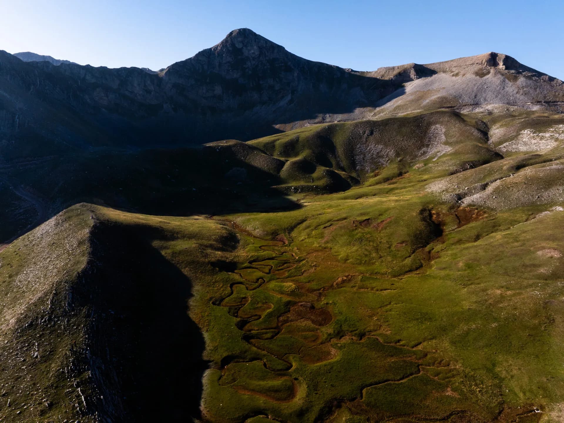
The Verliga plateau reveals itself at 2,050 meters. The word "Verliga" comes from the Vlach "Vringa," which means circle, meander. And that's exactly what you see: about ten meanders winding through the bright green plateau, like a sleeping snake. In these waters, the myth was born.
Locals say that a dragon emerged from the rock, crawling across the meadow, and carved out the twists with its body before disappearing into a hole in the ground. At the same spot where the water still sinks into a sinkhole, to reappear lower down and continue its journey to the Ionian.
Here the Acheloos begins to take form, from a network of springs fed by snowmelt. You're standing at the beginning of a river that will travel hundreds of kilometers.
What remains most vivid is the view. From Tsoukarela, if you dare the ascent, even better, the horizon opens to successive ridges that seem endless. First the Verliga plateau right below you. Further back, Megas Trapos. Even deeper, Tzoumerka and Kakarditsа rising like stone walls. And on the horizon, Tymfi, Smolikas, Grammos, faint blue silhouettes that resemble traces of mountains rather than masses. Atmospheric perspective gives the most distant ones a blue you don't find on any palette. You count and lose count.
We descended slowly, before it got dark. The descent is, psychologically at least, more demanding, since you see where you're going. Behind us, the mountain was preparing for winter. We entered Christos's café. "I had you on my mind," he told us.
Verliga: The Mysterious Water Wonder of Pindos
At Verliga: A Night That Redefines You
Verliga: A Seasonal "Lake" of Greece
Common Questions
How do I get here from Athens?
Most destinations covered on this site are 2 to 4 hours from Athens by car. I always recommend renting a car rather than joining a bus tour — you control your stops, you can pull over when something looks interesting, and the drive itself is often half the experience in Greece.
What is the best time to visit?
April to June is my personal preference — the wildflowers are out, the crowds haven't arrived, and the light is extraordinary. September and October are equally good. Summer is beautiful but you'll share it with everyone else. Winter is underrated and deeply local.


